Monday, February 16, 2009

Mount Singai

Mount Singai Mount Singai (1843 ft or 562 m) is located in between Bau & Matang area. The Catholic memorial & pilgrimage centre is located in the middle of this small mountain.This is a rest area where you can pray. They build long houses, and community complex. Instead of becoming the Catholic Centre this place is also open for visitors, those who love nature.The locals and visitors work together to carry the stone and other material using 'tambok' . These materials are used to build the community center. You can also do your part by carrying plastic bags of stone. (they prepared bags contain stone at the first step)

Thursday, February 12, 2009

Gunung Gading National Park

Plank Walk Trail

A comfortable plank walk makes the area where Rafflesia is commonly found accessible. The plank walk looms from a loop, which takes about one hour to complete, allowing time to enjoy the forest scenery along the way. Park rangers may be able to take you on a guided walk to a Rafflesia site and may even take you deeper into the forest if the plant is flowering there.

Waterfall

This trail is fairly easy and takes about 1 to 1.5 hours for a one-way trip. It follows the Lundu river and passes seven waterfalls, although not all of the waterfalls are accessible.

Gunung Gading Summit Trail

A challenging jungle trail leads up to the summit of Gunung Gading, which is the highest peak at 965 m. The summit trail is a continuation of the Waterfall Trail. The trees gradually become shorter and beginning at about 700 m elevation; this forest gradually gives way to lower montane forest. At the summit was the location of a British army camp during the communist insurgency of the 1960’s. Remnants of the camp, a water tank and barbed fencing, still remain.

Batu Berkubu

An optional trek from the Gunung Gading summit across a narrow saddle to Batu Berkubu is fairly easy but takes an additional two to three hours round trip. Trail markings are painted on the trees, but may be difficult to see during dark, rainy weather. The saddle has beautiful forest scenery. Batu Berkubu, which is on the flank of Gunung Sebuloh, served as a communist base camp during the insurgency.

Perigi Trail

This is a four to five hours journey (one way) – the most challenging trek in the park. The trail was not marked and it is highly recommended to do the trek accompanied by a park guide. A signpost indicates where the Perigi Trail branches off from the Gunung Gading Summit Trail (this is about 30 to 45 minutes walk beyond the 7th waterfall). The trail initially leads through dipterocarp forest, which as on Gunung Gading, from about 700 m elevation gradually gives way to lower montane forest. Those who complete the Perigi Trail will be rewarded with a breathtaking all-round view from Gunung Perigi at 955 m elevation.

Things to do here

  • Flora gazing
  • Jungle trekking
  • Mountain climbing
  • Photography
  • Swimming

Getting There

The Park is just five minutes drive from Lundu town or about two hour's drive from Kuching. You can take Sarawak Transport Company (STC), Lundu Express Bus or Bus No. 2B from Kuching City to Lundu town centre. From there, take a Pandan bus and ask to be dropped off at the park. As accommodation facilities in the Park are limited, hostels in Lundu Pandan and Siar offer alternatives. Beaches at Siar and Pandan are scenic and provide swimming spots. Visitors can choose either day-trips or overnight stays when visiting the Park.

Tanjung Datu National Park

Description

Tanjung Datu National Park is situated at the westnmost tip of Sarawakon the Datu Penisula. It is one of the smallest parks in Sarawak, with an area appromiximately 14 kilometres square (1,379 ha). Gazatted 16 March 1994 and published to public on 19 May 1994 and was formerly known as Labuan Gadong. Half of the peninsula is situated within Sarawak and the other portion lies in Kalimatan Indonesia. The park is also described as the "Heaven of Borneo" by foreign visitors.

Interesting natural features with splendid rain forst and unique coral reefs make the park an exceptionally signficant area for biodiversity. Its pristine envirnment with a series of mountain ranges and luxurious mixed dipterocarp forest and fauna make the park a pleasant place to visit. The unpolluted crystal clear water of the South China Sea provides a wide range of marine life, which could be prime attraction to those who love snorkeling and scuba diving. Turtles are another possible attraction to the visitor because the park is one of the few destination for the turtles landing to lay eggs. Due to its location being quite remote and isolated, the park offers a spectacular destination for nature-based tourism attraction.

The Park has yet to be officially opened to public. However, visitors cen get a permit to visit the park from the Sarawak Forest Department and get there by hiring a boat from the coastal town of Sematan. The journey from Sematan to Tanjung Datu National Park, approximately 40 minutes. During the monsoon season from October until February the sea condition is often too rough for small boats. Usually small boats are not allowed to travel at the time of the year. Visitors to the park are encouraged to travel during the month of April to September when the sea is calm.

Interesting attraction

Northern Shoreline

The shoreline to the north of Teluk Labuan Gadong is rocky with large granite boulders. There are small narrow beaches at Pasir Antu and Pasir Berunput. These area is very scenic with rugged mountain in the background. In the morning especially in the morning., it is possible to hear the call of the gibbon and it would be best to travel along this coastline by kayak in order to fully appreciate for the natural beauty of the unspoiled environment.

Cliffs

The main cliff area is at Tanjung Labuan Gadong and is approximately 80 meter in height. These cliffs are composed of altered sedimentary rocks. Inland from the cliffs is a viewpoint and from the top it is possible to see the entire shoreline of the park to the north, Teluk Upas and Teluk Jin Siong to the south and also the village of Teluk melano and the surrounding areas. On a clear day dolphins can be seen swimming near to the bay.

Marine Life

The area has an abundance of interesting and varied marine creatures from dolphins to whales, flying fish, turtles, king crabs, octopus, sea anemones and corals.

Inland

The interior of the park is comprised of steep mixed dipterocarp forested mountains. There are many different animals species in the forest like gibbon, long tail macaques, bearded pigs, tufted ground squirrels, peacocks, mouse deer, barking deer, sambar deer and hornbills.

Accommodation

There are no accommodation fercilities provided in the park, but they is a "home-stay programme" which was initiated by the Sarawak Tourism Board, that involved the local people in order to provide a cultural experience of everyday Malay village life. This stay inculde staying with the local family, eating the same food as the family and joining in their cultural evenet and activities. A local tour agency (Borneo Inbound) was appointed to conduct the hoe-stay experience.

This park will be open for visitors in the future.

For booking and further enquiry, please go On-line booking click http://ebooking.com.my

A Short History of Lundu.

As far as anyone knows, the lands around Lundu was empty of people until relatively recently. Although the main river is called Batang Kayan, "the Kayan river," there is no evidence at all that any Kayan people ever lived there.. In the middle of the eighteenth century a group of Bidayuh people from near Bau migrated and settled on the west bank of the Batang Kayan, where Kampong Stunggang Melayu now stands. They came to be called the Dayak Lundu, and though the last member of the tribe died in the 1960s, you can still see the grove of durian trees they planted. The name "Lundu" itself is taken from a small catfish that abounds in the Sungai Lundu which flows down from Gunung Gading. Towards the close of the eighteenth century three groups of people at the same time came separately to make their homes in Lundu. From the east came the Ibans. These Ibans were originally from Balau on the west bank of the Batang Lupar. They spoke, and still speak their own dialect of Iban and traditionally had been enemies with the Ibans of the Saribas and Paku areas. A group of Balau people decided to mindah, migrate. They stopped first at Sebuyau, and from there travelled west. From their stay at Sebuyau they have kept the name Iban Sebuyau. Part of them, it seems, came overland, and made settlements along the way in the Samarahan area, at Kuap, and in Kuching. Another part, led by their chief, Nyambong, went by sea and first established themselves near the sea at the mouth of the Batang Kayan. Later the Sebuyau moved upriver and built a longhouse on the east bank of the Batang Kayan to the ulu of the small Sungai Stunggang. The present Kampong Stunggang Dayak occupies the site (more or less; at least an acre of land has been lost to the river by erosion) of the old longhouse. On his first visit to Kuching in 1839, James Brooke, later to become the first Rajah of Sarawak, met the headman of the longhouse, Jugah. According to custom, the longhouse was called Rumah Jugah, "Jugah's Longhouse." Jugah invited Brooke to visit Lundu, and spent his first time among Dayaks in the welcome company, I am proud to say, of my son's ancestors. The Sebuyau remained Brooke's favorite tribe, and they performed heroic service in the Rajah's campaigns against the "pirates." The Lundu chiefs bore the title of Orang Kaya Pemancha, "Rich-Man, Commander," after Jugah had been ennobled by the Sultan of Brunei in the early nineteenth century. This historic line came to an end in 2003 with the death of O.K.P. Kalong, a direct descendent of Nyambong and Jugah, at the age of 93. As the Sebuyau were coming to Lundu from the east, Chinese and Selako settlers were arriving from the west, over the hills that separate Sarawak from what is now Indonesian Borneo. Chinese had been living in Pontianak and Sambas for a hundred years or more. When gold was discovered in Bau, Chinese migrated there and established their kongsi, "commercial republic." Along the way a number of mainly Hakka Chinese, settled in the Lundu area, first of all, it seems, at a spot about a mile to the ulu of Rumah Stunggang, where they began to grow vegetables to sell to the Sebuyau. Many Chinese people in the Lundu district make their living by gardening pepper. Before the Brooke era, and well into it, life at Lundu was centered on Rumah Stunggang and the nearby area where Brooke established a fort and offices. The present Christ Church, which replaces the first Christ Church built in 1863, overlooks the site of the old fort and its landing. It is unclear when Lundu town began to assemble itself at the present location about a mile to the ili’ on the river. Some sort of pasar must have existed in the second half of the 19th century, for the Lundu District Officer wrote in the 1870s to report on Chinese secret societies. The smaller Chinese temple across the road from the bigger temple by the bus station was built in 1893. Also from the west came the Selako or Selakau. The Selako are Dayaks; their language and culture is related to the Ibans', although they are distinctly different. The Selako claimed the land from west of the Batang Kayan to Sematan. As Lundu became a regional center, Malays also came to settle from the Natuna Islands. What is wonderful about Lundu, is that although four different people settled very close together, there has from the beginning never been any friction between them. The reason for this cordiality is, I believe, that all three peoples came to Lundu to seek a better life, and each people pursued their aim in a way that did not compete with the others. The Sebuyau were interested in developing low-land rice, and they traded their surplus to the Malays of the Natuna Islands for salt fish, sugar, and other goods. The Chinese came to trade and to farm, and the Selako also appreciated security and prosperity. The Selako now supply Lundu with vegetables and fruits from their gardens. The Malays fished on the sea. The Saribas Ibans made one attempt to wage war on the Lundu Sebuyau in the early 1800s. Their war-boats were blocked by an emormous boom laid across the river; the Sebuyau had cannon, and the Saribas were defeated and forced to retreat. Since then Lundu has been at peace, with the exception of two periods: the Japanese occupation and Konfrontasi, the guerilla war waged on Sarawak, then part of Malaysia, by Sukarno's Indonesia. The Japanese occupation was a time of hardship and anxiety for Lundu people, but they suffered nothing more painful than shortages of food and goods. Konfrontasi was a small war, but brought tragedy. Local people were killed by Indonesian guerillas, and some younger people of Lundu lost their lives after having joined the communist insurrection supported by Indonesia. The memories are painful. Lundu had electricity and piped water (from Gunung Gading) by the early 60s. Piped water came to Kpg. Stunggang Dayak in 1987, and electricity was extended to our kampong in 1988. The Lundu hospital was built in 1965, and now offers treatment for all except the most serious problems. They have a dental clinic and ultrasound screening for mothers-to-be. Until 1968 Lundu could be reached from Kuching only by boat. In that year the road from Bau to Lundu was completed and regular bus service began. This road remained a gravel-surfaced road until 1995, when the whole stretch was improved and asphalted. About 5,000 people live in or close to Lundu town. The total population of Lundu district was about 25,000 when figures last became available. People in Lundu make their living in traditional ways, by farming, fishing, planting cocoa, pepper, and rubber, although rubber is less important than it was. There is a smidgen of light industry, and the palm-oil plantations that line the Bau-Lundu road and across the river towards Sematan, together with the factories for the extraction of the oil, employ many people. Trade to supply the needs of primary economic contributors is vigorous. When the bridge over the Batang Kayan is completed, we are expecting new opportunities in tourism and other things.

Otto's Lundu Part 5

Les Délices de Lundu,

or The Delights of Lundu,

together with Information Useful to Visitors.

Getting Around

If you don't have a car or a motorbike, getting from place to place in the Lundu area is difficult. Busses run to Sematan, and to Kampong Pandan, but are infrequent and service stops mid-afternoon. There are no taxis in Lundu, nor bicycles for rent, and distances are too great conveniently to walk. Bear this in mind when you make plans. Tour operators in Kuching regularly bring people on excursions down to Lundu, and a day-trip with transport is easy to arrange.

Gunung Gading National Park

You have already seen the three beautiful peaks of Gunung Gading, a handsome basaltic mountain directly to the west of Lundu town. From here comes our water-supply, excellent pure mountain water. The whole of Gunung Gading is gazetted as Gunung Gading National Park. Miles of trails lead through the forest to outlooks and waterfalls. Some of these are arduous. Lower down the park authorities have built a raised boardwalk of belian wood through the forest. [Note: in Sarawak, "forest" means untouched growth; secondary growth is called "jungle."]
This walk makes a circuit of about a kilometer. There are many places in the woods just off the trail where the Rafflesia can be seen in season. Now and again other wonderful exotic flowers will bloom. The guides at the park are very well informed. If you telephone the park, they will will be happy to tell you if a Rafflesia is in bloom, and when you get there, they will guide you to the flower for a small fee. The Gunung Gading National Park Website can be found here. Admission to Gunung Gading Park costs RM10.00 for adults and half that for children. Be advised that there are fees charged for bringing in still and video cameras. Inside the entrance to Gunung Gading Park one finds a building with offices for the rangers, and attached to that a small museum built in the shape of a Bidayuh "headhouse." Here you may see a topographical model of the mountains and park, and exhibits on the Rafflesia, other interesting wildlife, and curious spots. During the early years of the 1960s, when Indonesia and Malaysia were engaged in an undeclared war called "Konfrontasi," adherents of the communist movement hid themselves in the forests of the mountain. This was a tragic time. Sons and daughters of local people joined the communist movement, and some were killed by British forces putting down the insurgency. Gunung Gading National Park also has a spot for having picnics, and for camping. The park also has chalets and shared rooms which one can book for the stay of one night or several. A beautiful mountain stream pours down from the summit into a sandy-bottomed pool not far from the main buildings. This pool, at the head of the boardwalk trail, is a favorite picnic and swimming spot for both local people and for visitors from Kuching. The water is crystal clear and cold. Little fish, if you're patient, will come up and nibble on your toes. This is a very pleasant place to spend a afternoon getting away from the heat. The scenery is very beautiful, and the absolute true picture of the Romantic Tropical Jungle. The photo on the left shows Sam under water in the pool. The other is Sam with my late brother Karl. NB. On weekends there are lots of people there, and the water can get roiled up and a bit murky. The short road to Gunung Gading National Park opens up on the left side of the road out of Lundu towards Pandan, about a mile from the center of town. This entrance is obscured by a tight curve, and I urge people who are driving there to be careful. For more information go to: http://www.forestry.sarawak.gov.my/forweb/np/np/gading.htm, the Forestry Dept.'s website on Gunung Gading, or to the Sarawak Tourism Board's Gunung Gading website: http://www.sarawaktourism.com/gading.html

Siar and Pandan Beaches

Two beaches lie to the west of Lundu on the South China Sea. The first is Siar Beach, and at the end of the road is Pandan Beach. Both have their associated Malay kampongs. These beaches, and particularly Pandan Beach, are popular places that people from Kuching visit on weekends. During weekdays they go back to being Deserted Tropical Beaches—except for a few fishermen coming in and out. The water here is warm and clean, although not exceptionally clear because of the waves on shelving sand. At high tides the water will reach the very limit of the sands, and during monsoon season the surf can be violent. The sea here is not suitable for diving, nor for surfing. It's a place to go swimming and to walk. Pandan Beach extends for about a kilometer in the shape of a shallow crescent. A rugged jumble of basalt sits on the western end, and an equally rugged hill with cliffs on the eastern. One small shop sells drinks and snacks, and the villagers have built a public toilet where one can shower off with fresh water after swimming. Along the road from Lundu to Pandan near the beaches there are a handful of resorts. We have no personal experience of these, because we live here. They are certainly worth looking into. As I update this page I will include names and phone numbers. Places to Stay, Places to Eat. People who are mostly interested in visiting and hiking in Gunung Gading National Park will do best making a booking to stay in one of the Park's chalets or shared rooms. Or they can bring camping gear and set up a tent on the grass. If you do stay there, be sure to stock up on food and drink while you are in town, as the Park has no canteen. The markets in Lundu are full of good, fresh food. Fish is best bought early in the morning. The catch comes at high tide. The vegetable market is in my opinion better than Kuching's. Lundu town does not offer much accomodation. The small Lundu Gading Hotel is located on the back side of the Padang, towards the mountain and facing the RHB Bank. The Lundu Gading Hotel is your basic utilitarian Chinese hotel, although the rates are somewhat higher than average. There is also the Hak Cheng Rooming House, on the opposite side of the same street, of which, again, we have no experience, not even to know if they take tourists. In future new places, including homestays, may appear. Lundu town has plenty of good places to eat. We have many coffeshops that serve drinks, including beer. Ask for the special: three tins of Tiger Beer for RM10.00, instead of getting bottles. I enjoy beer in Singkeh's coffeeshop, on the north-east corner of the Padang facing the Shell station. Singkeh's shop is quiet and clean. Most coffeeshops also serve noodles, chicken-rice, and such, although many people stop cooking after noontime. Food is served all the time in the "food court" on top of the Vegetable Market. We especially recommend the coffee/noodle shop on the south-west corner of the Padang, opposite the fish-market. Also the Happy Seafood Center, a delightfully breezy shop on the corner of the new shophouse row, facing the Agriculture Dept. The best place in town is the seafood place right next to the bus-station, in the row next to the Chinese temple. They do fish and prawns very well. Miscellaneous note. To get a newspaper---if you like to read the paper with your coffee---go to the stationery store on the S-W row of shops on the Padang. English papers sell out early!

Other.

From the map on Lundupage Two, I think you will be able to find the bank, post office, and other places you may need to go. The Hospital is located about 300 m from the post office on the left side of the road towards Pandan. Dr. George Paulus Sabang has a private clinic in the newest row of shophouses opposite the Agriculture Dept., down from the Happy Seafood Center. To make phone calls you will need a phone card, as the Telekom office, next to the Post Office, is a small purely administrative affair. An internet café came and went; it may be possible to send an e-mail from the computer tuition center—also in the new shophouse row—or from the District Council office.

To the West of Lundu.

The main road goes west from Lundu to Sematan and Pueh. Not far out from Lundu towards the west one can turn left, to the south, and drive up an improved road to Biawak, on the border with Indonesia. There is not much there except a very small pasar connected with an army camp. Before Sematan, also to the left, is a farm that raises silkworms. All views from the hill are beautiful, the mountain at the back beautiful, the air is cool and the silkworms are pretty cool too. The hill is planted thickly with paper mulberrys, Broussonetia papyrifera, a member of the hibiscus family. The Tahitians, Hawai'ians, and other peoples of the Pacific made their famous tapa cloth out the inner bark of this plant, although I do not believe that Borneo people ever used this for bark-cloth. Off of Sematan, slightly to the east, lie the two "Turtle Islands," Talang-Talang. These have been administered by the Sarawak Museum as a sanctuary for sea-turtles since the 1950s, when Tom Harrisson established a conservation program. The Museum has a bungalow on the main island. This used to be available for people to stay in, but when I last inquired I was told that the island was closed and the building being repaired. I took the photo below from the vantage of the silkworm-farm. Sematan is a very small town with, as I remember, exactly one place to eat, and one place to stay. The beaches at Sematan and at Pueh, still further to the west, are all of very, very gradually sloping sand, so that you may have to walk out a quarter of a mile at low tide to get to the water. Plenty of casuarinas. Nonetheless, there are apparently some very good sites for scuba diving around Sematan. A Mr. Law runs the Sematan Scuda Diving and Water Sports.

Otto's Lundu Part 4

Within Lundu Town.

The Malay word for "town" is pasar. This derives from the Persian bâzâr, and means "market." People say, "I'm going down to the pasar," in Malay, Iban, Selako, and English (or, alternatively, in English, "I'm going down to the bazaar") as often as they say, "I'm heading for town." The market is the town, the town is the market. Few people actually live in the pasar except for the (usually Chinese) owners of retail businesses and coffeshops, and their families. Everybody else lives outside the pasar, in one kampong or another, or in a house on a separate plot. An open shop at the Dry Market. As the name suggests, the Dry Market is where things like salt fish, beans, rice, coffee, and sundries are sold. Directly facing the dry market is the bus-station. The Kuching busses arrive and depart from here. And there is service to Bau in the east, to Sematan and Pueh in the west, and also to Kampong Pandan. By this last route one may get to Gunung Gading National Park---about one mile outside of town---and to Siar and Pandan beaches, which are considerably further out. At the center of Lundu town lies the padang or square. Shophouses line three sides of the padang, and the third side is open to the river. Here we are looking NW from the river side. From the back area of my office, one has a complete view of Lundu's Wet Market. Here are sold vegetables, fruits, and other things. Upstairs in the main building is a "food court." Traders in the main building specialize in vegetables grown by commercial farmers outside Kuching, and in imported fruits such as apples. Many of the traders here also grow and sell their own vegetables and fruits, such as cucumbers and citrus. To the left of the main building stands a large oven pavilion. Here Dayak women bring the vegetables they grow to sell. They will also sell the jungle produce they collect: ferns (midin and paku), bamboo and palm shoots, and wild fruits. Women traditionally take care of this type of business. The old District Office, built by the British during Sarawak's brief time as a colony.

Otto's Lundu Part 3

Lundu Town & Map

Lundu from the air, facing west. South China Sea to the right. (imperfectly scanned)

Sketch Map of Lundu Town

Key to Map.

1. Bus station 2. Lundu Hospital 3. Post Office 4. District Council 5. Public Library 6. RHB Bank 7. Fish market, poultry market, pork market, dry market. 8. Vegetable market 9. Petronas gas station (next to a Shell station). The green square in the center is the Padang, and is surrounded on three sides by shops.

Otto's Lundu Part 2

The Batang Kayan.

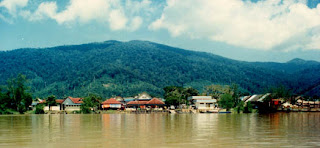
Looking from the old Ferry Point towards Gunung Gading and the sea. The District Office shows in the center. If you stand at any point on a river's course, the area downriver of you is called ili’, and the area upriver from you is called ulu. These are two important direction-words in Sarawak, for even in the present much travel has to be done by boat. We are looking towards the ili’. View of the ferry landing from the Lundu side of the river. The bridge remains under construction. [Already complete! 7 July 2005] The Batang Kayan is a tidal river, and the distance between high and low water during new moons can be twelve feet, or more in monsoon season. A bridge over the Batang Kayan had been planned for many years. In 1996 the government announced that a design was ready and a few years later work began. Here is the bridge so far in its construction as it appears from the Kuching side of the river, photographed in February 2004. We expect the bridge to be complete in late 2005 or perhaps 2006. [And now it's done!!] We have gone to the ulu of the ferry point about half a mile and are facing Kampong Stunggang Dayak. The houses are hidden by the trees. Signs of habitation here are coconut palms and the boat moored at the bank. Coconut palms do not plant themselves. They are like apple trees in New England. If you see coconut trees, you know that someone lives there, or used to live there. Kpg. Stunggang belongs to the Sebuyau Iban people. Baki Resol's (my wife Nusi's father) house is behind here. In 1839 James Brooke, not yet rajah, first spent a night in the longhouse that existed on this same site. The Sebuyau switched to living in separate houses after WW II.

Otto's Lundu Part 1

Otto’s Lundu Page

Information for the traveller, and appreciation of the place where we live.

This web-info, i get it from Otto's Lundu, not knowing him though, but cool, covers Lundu. Bravo Otto's.
http://www.ikanlundu.com/lundu/lundupage1.html Gunung Gading becaban tiga, Pantai Pandan jauh ka tengah. Ancur badan di-kubur tanah Budi baik di-kenang juga.
"Tusk Mountain has three peaks, Pandan Beach stretches far to the middle. A person's body may be dissolving in the grave; A kind heart is remembered always." ---as recited by the late Hbi anak Muda (our son Sam's grandmother). The Arms of the Lundu District Council (Majlis Daerah Lundu) : Above, Gunung Gading; a Rafflesia; Pandan (and/or Siar) Beach, and water that can be both the Batang Kayan (Kayan River) and the South China Sea. The town's "totem animal," from which it takes its name: an ikan lundu, literally "lundu-fish," a freshwater, bottom-feeder, catfish like thing, "Arius or Macrones species" (Anthony Richards, An Iban-English Dictionary.) Photographed at the Sematan (alas) fish-market, 17 June 2005.

Introduction

Where Lundu Is. And How to Get There.

1° 40' N 109° 50' E
Lundu lies in the west of Sarawak, on the west bank of the Batang Kayan (Kayan River), and not far from the South China Sea. The road from Kuching to Lundu measures, all in all, about 90 km. •By car: From the center of Kuching, take Rock Road to Third Mile bazaar, and continue on Batu Kawa Road. At the time of writing (25 March 2004) Batu Kawa Road is being widened, so expect obstructions. Continue over the Sarawak River Bridge and straight to the end. Turn right (to the west) and drive straight on the Bau-Lundu road. NEW! At last, the bridge that carries the main road over the Batang Kayan river is complete! It was opened on July 7, 2005. Travellers to Lundu will no longer have to wait for a ferry---a business that was tedious at the best of times and truly gruesome on holidays. I have seen a line two miles long of cars waiting their turn to be carried over. Nobody is happier for having a bridge than us locals. Now we can do our shopping when we please. Follow the signs. Once on the west bank of the river one can turn right and reach Lundu town by the road through the Malay kampong. Drive slowly, children are playing, and watch for speed-bumps. Note for those who get hungry: Half a mile before the Batu Kawa road joins the Bau-Lundu road, on the right/west side of the road, is the Red Dragon Café. The Red Dragon (the only non-Chinese dragon in the whole of Sarawak---it's Welsh) is the best local-style restaurant I know. The food is excellent, and the restaurant is spotlessly clean. The proprietors, Mr. Richard Hughes and Tata, his wife (the café is in her kampong) also serve the best British breakfast in the country, with real pork sausages and bacon. Their conversation is fully as valuable as their cookery. Please tell them I sent you. •By bus: The Sarawak Transport Company runs four busses in each direction from the Kuching Express Terminal at 3 ½ Mile. Trip time is about one and a half hours. The Express-Bus Terminal is best reached by taxi.
Kuching to Lundu Lundu to Kuching
8:15 a.m. 8:00 a.m.
11:00 a.m. 11:a.m.
2:00 p.m. 2:00 p.m.
4:00 p.m. 4:00 p.m.
One can also take a local bus from Kuching to Bau, and change at the bus station there to a local bus to Lundu. This is better for seeing interesting things out the window.

Places to Stay: Lundu and Sematan

1. Siar Beach Resort. Located at Siar Beach outside of Lundu, further down the road from Gunung Gading National Park. From their advertisement in the Sarawak Tribune: "•Fishing • BBQ facilities • Fridge • Electricity • Master Bedroom with air-conditioning and bathroom attached." Telephone: 082-572300, mobile: 019-886 9478 2. Lundu Gading Hotel, Ang Yong Huat, manager. Located in the center of Lundu town, across from RHB Bank. Lot 174, Lundu Town District 94500 Lundu, Sarawak Tel/Fax: 082-735199 Mobile: 019-858 6529 Room rates: RM 58.00 per room per night. Air-conditioning, bathroom/toilet, TV. 14 rooms in all: 12 rooms with 2 single beds, 2 rooms with double bed. 3. Gunung Gading National Park Trekkers will probably wish to put up here. The chalets and other rooms are right in the park, and if you rise at dawn (always at 0630 or thereabouts throughout the year----we are on the equator----you'll get in a full day's scampering over the mountains, with time at late afternoon for relaxation. Be advised that Gunung Gading N'tl Park is over a mile from Lundu town, and that busses to and fro can be caught only 500 m from the Park, on the main road, that they run infrequently, and cease in the mid afternoon. The following information is taken from http://www.forestry.sarawak.gov.my/forweb/np/np/gading.htm Please visit there for fullest information, including phone numbers for other national parks. Gunung Gading Park has two chalets, each with three bedrooms, and one domitory-style hostel consisting of four rooms each containing 16 beds. Campsites are available. • The "Forest Lodge" chalets offer a double bed in Room 1, and two single beds in each of the other two other rooms. The rooms are air-conditioned. The rate is RM150 per night. • The "Forest Hostel" offers four rooms with two bunk-beds each. Bathroom and toilet is shared. The rooms are not air-conditioned. The rates are: RM15 per bed, or RM40 per room. • A campsite, with access to bathroom and toilet, is available for RM5 per person. There are ten sites. 4. Sematan Hotel A small, modest hotel on the main road into Sematan, about 500 m before the T-junction, on the left. Twenty-three rooms, with air-conditioning and shower, at RM25 per night. For food, you must go to the bazaar. Laundry can be done. Tel/Fax: 082-711162 5. Sematan Palm Beach Resort. In Sematan, the furthest town to the west in Sarawak. To reach the Resort, take the road from Lundu to Sematan straight to its end in a T-junction in Sematan bazaar, turn left, and head west, allowing for bends and junctions in the road. If you stop in Sematan bazaar, inquire at the Hing Moh supermarket, on the corner after the fishmarket and bus-station. I reproduce their brochure.-----------
Room Tariff (Effective 13.11.04)
Room Types Eve of Holidays & weekends Weekdays
Detached Chalet (4 pax) RM330 nett RM280 nett
Quadruplex Chalet (2 pax) RM180 nett RM153 nett
Terrace Twin (2 pax) RM140 nett RM130 nett
Terrace Family (6 pax) RM 390 nett RM331 nett
• Above rates include dinner & breakfast • All rooms fully air-conditioned, equipped with TV and en-suite toilet cum bathroom with heater • Check-in : 2 p.m. Check-out : 12 p.m. • Deposit payable upon confirmation of rooms • Group rates negotiable • Above rates are nett, including of [sic] service charge and govt tax • Rates are subject to change without prior notice Other Facilities • Conference room • Restaurant • Rental of BBQ pits RM15/unit • Rental of Majong table RM15/unit Recreation • i. Kayak rental Single RM10 / hr Double RM15 / hr ii. Bicycle rental RM 5 / hr iii. Climbing wall RM5 / hr iv. Diving, snorkeling Prior arrangement • Non-stay-in guests Entrance fee per day: Adult RM2 Child RM1 For reservation & inquiries Sematan Palm Beach Resort No. 12, Sematan Bazaar 94100 Sematan, Sarawak Tel: 082-712388, 082-711112, 082-7111128 Fax: 082-711177

Sarawak

Sarawak has been described as Asia's " Best Kept Secret". Now the secret is out. Sarawak is the place for history, mystery, romance and exotic adventures. The land of the fabled White Rajahs, the hornbill and the orang utan, Sarawak is the largest State in Malaysia and by far the most exotic. Sarawak is situated in the north-west of Borneo. East and borders Brunei, Sabah and Kalimantan, Indonesia. It is the largest state of Malaysia covering an area of 124,450 square kilometres (48,342 square miles) with a coastline 720 kilometres in length which accounts for about 37.5% of area of Malaysia. Its highest point is Gunung Mured, 2,438 metres, and has the longest river in Malaysia, Batang Rajang, which stretches over 640 kilometres. Sarawak, with an average rainfall of over 200 inches per year, is an expansive network of rivers, rainforests, mangroves, swamp forests, mountains and has the world`s oldest limestone caves. Sarawak is a tropical country with an equatorial climate. It is hot and humid throughout the year with mean daily temperature ranging from 23° C during the early hours of the morning to 32° C during the day. It experiences two monsoonal changes. The West Coast East Monsoon, which usually occurs between November to February, brings with it heavy rainfall. The South West Monsoon is usually less wet. Except for monsoonal changes, the climate remains fairly stable throughout the year. Annual rainfall varies between 330 cm to 460 cm for the greater part of the country.

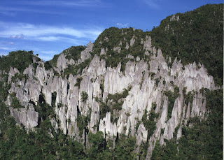
The Pinnacles the famous Pinnacles of Mulu National Park.

The Pinnacles at Mulu National Park are a collection of 45 metre high, limestone needles that cling to the side of Gunung Api (Fire Mountain). They form a forest of silver-grey stone encircled by thick green vegetation. A trekking trail leads to a small viewpoint overlooking the Pinnacles and the ‘Pinnacles Summit Trek’ is one of most popular treks in the park. The trek to view them is one of the most popular in the park. But be warned, the Pinnacle Summit Trek is a tough and challenging one.

The trek requires a reasonable level of fitness as parts of the trail are very steep. It is usually done as 3 day/2 night trip although it is possible to opt for a 2 day/1 night trip if you are in good physical condition. The first part of the journey is a pleasant 1-2 hour boat ride along the Melinau River from the Park HQ to Kuala Berar. If the water level is low, the boat has to be pushed over rocky sections so the trip takes longer. It's followed by a 7.8 kilometre jungle trek to Camp 5.

The real hiking begins the following morning. The climb is challenging, filled with fun and excitement. The trail is 2.4 km in length but rises some 1,200 metres. Vegetations vary following the changes of altitudes. The varieties of wild orchids and pitcher plants scarcely seen elsewhere can be spotted along the trek before reaching the Pinnacles. The last section of the trail is near vertical, with rope sections and 15 aluminium ladders strategically positioned to help with the climb. The vegetation is sparse although orchids, rhododendrons and pitcher plants thrive in the area, and can be seen at the side of the trail. The viewpoint area is made up of a number of pinnacles, rocks and vegetation and has excellent views of the silver-grey forest of stone that rises up from the surrounding vegetation. Fit and experienced trekkers should be able to reach the top in 2-3 hours. The not so fit but determined generally take around 4-5 hours. Most people spend an hour or so at the top, taking photos, resting and having a bite to eat before beginning the descent. The descent may take slightly longer than the climb.

Orang Utan

Cute, cuddly, gentle and endangered, that's pongo pygmaeus better known to the world as orang utan. They have a brown and rust-coloured shaggy fur. Orang utan means "the man of the forest" in Malay. In times past they didn't kill them because they felt the orang utan was simply a person hiding in the trees, trying to avoid having to go to work or become a slave. Orang Utans are the largest tree-living mammals and these fascinating and very human ginger apes gave rise to the legend of the Wild Man of Borneo. Females have a body weight of 37kg, and males weigh 83kg and their life span is about 60 years. The orang-utan lives in tropical, swamp and mountain forests, where it eats mostly fruit, leaves and insects. The major causes of the orang-utan's decline have been:

1. in the past, capture for the pet and zoo trade, especially the capture of young, which usually involved killing the mother.
2. loss of habitat loss, especially through permanent conversion to oil-palm plantations and for logging.

Orang utans are highly intelligent with an ability to reason and think. This large, gentle red ape is one of our closest relatives, sharing 97% of the same DNA as humans. The orang utan has the most remarkable ability to travel through the forest treetops. They make their home in these trees and build nests each night out of leaves and branches in the very tops of the trees. This is where they live and sleep - sometimes as much as 100 feet above the ground. The orang utan has little need to come down from the trees, as they are uniquely adapted for their arboreal lifestyle.

Almost all of the food they eat grows in the treetops and the frequent rains fill the leaves thus supplying their drinking water. When water is difficult to get, they chew leaves to make a sponge to soak up water in tree cavities. When it rains very hard the orang utan makes an umbrella for himself out of big leaves.

Sarawak has the biggest wild population of these threatened apes that are found only in Borneo and Sumatra. Shy and solitary by nature they are hard to see in the wild. They travel across vast ranges of forest browsing for fruit and making a new tree nest each night. Although second in size only to the gorilla among the great apes, the orang utan lives almost completely in the trees. Swinging from branch to branch takes enormous strength. Orang utan females only give birth about once every 8 years - the longest time between births of any mammal on earth. This results in only 4 to 5 babies in her lifetime. This is why orang utan populations are very slow to recover from disturbance.

Man's encroachment on their forest habitat, coupled with their low birth rate has seen a marked drop in orang utan populations, particularly outside Sarawak. Here they are totally protected and the population seems to be increasing. There are strict laws against keeping them as pets. Any found in captivity are confiscated and taken to rehabilitation centers at Matang and Semmengok, both near Kuching. Here they are taught how to fend for themselves in the forest before being released. On Sabah you can visit the Sepilok Orang Utan Rehabilitation Centre.

These centers are the best places to see orang utan, both those under rehabilitation and ones that have been released but still return looking for handouts of fruit from the wardens.

Longhouses

In Sarawak, the dominant tribal groups are the Dayak. Tribal people live in longhouses. There are the Iban (Sea Dayak), and the Bidayuh (Land Dayak). All of Malaysia’s tribal people feel a strong spiritual connection to the rainforest. The Iban grow rice and fruit, and hunt and fish. The longhouse is the very centre of communal life in Sarawak. There are over 4,500 longhouses in Sarawak. These communal houses, built on stilts, may contain up to 100 individual families in separate 'apartments' built under one long roof.

The rainforest is home to 27 ethnic groups each with own distinct language and culture. The real longhouse experience begins with the journey upriver. River travel in a perahu - a shallow draught canoe - affords you the pleasure of seeing Sarawak at its best. Longhouses differ slightly from tribe to tribe but share the same basic characteristic. The Iban are the largest tribe in Sarawak and one of three native peoples whose past includes the practice of headhunting. Heading upstream, your boatman will take you along idyllic waterways with white pebble beaches, under the over-arching branches of tropical hardwoods, whose dense emerald foliage allows through only a dappling of sunlight. As you meander upstream, and your boatman punts through the river's shallows, kingfishers glide past, hornbills fly overhead, and local children dive from the riverbank into the cooling waters. Longhouse inhabitants are very well known for their hospitality. It is normal for people to just turn up and expect to be invited in by the headman (gifts are expected in return). As you arrive at the longhouse, it is customary to be greeted by the longhouse maidens and young men performing traditional dances and playing ceremonial gongs. At the entrance to the longhouse there is a wooden arch with small baskets made of palm leaves hanging from the top. Offerings such as a few coins or a cigarette are occasionally put into the baskets and help keep evil spirits out of the longhouse. From the moment you step inside the longhouse you will be treated as an honoured guest. Visitors will be offered a glass of tuak - the very palatable local rice wine. Or more often than not, several glasses of tuak will be offered to wash down a banquet of local delicacies. Then your hosts will start beating the gongs. This is the cue for the traditional dance, usually the Ngajat. The inspiration for the graceful movements of the dancers comes from the effortless flight of the hornbill, Sarawak's emblem. Then your newfound friends will enthral you with stories of Sarawak's legendary past. Usually a longhouse party lasts all night. As the sun is eclipsed by the moon, weary from your day's travel, and a night of dancing and feasting, retire to the ruai- a covered verandah - for a good night's sleep.
In recent decades much of their rainforest has been cleared by logging and plantation companies. The Iban and other tribes have frequently blockaded logging roads to try to protect their forest.

In many Iban longhouses you find only old people and young children. I got the feeling that the whole community is reduced to an exhausted past, and an uncertain future. Naturally, without the younger generations to inherit their rich cultural legacies, but traditions are dying. The ancient crafts of making boats, building longhouses, weaving, dancing, tattooing, and native art are now dying fast. Even the whole oral tradition of telling tales and myths is disappearing.

The Iban

Closely connected with the death cult is the headhunting activities of the Iban long ago. In the past, head trophies ( antu pata ) were secured to ceremonially end the long and strict period of mourning after a death. Other important occasion which required the acquisitions of head trophies include-- the death of leader, and the birth of a child, especially a male child. Head trophies were also acquired during bejalai missions of tribal warfare. The acquisition of head trophies was a sign of valour in battle and brought prestige to the conquering warrior.

In Sarawak, the dominant tribal groups are the Dayak. Tribal people live in longhouses. There are the Iban (Sea Dayak), and the Bidayuh (Land Dayak). All of Malaysia’s tribal people feel a strong spiritual connection to the rainforest. The Iban grow rice and fruit, and hunt and fish. The Ibans form the largest percentage of Sarawak's population, making up some 30% (= 400,000 people). Reputed to be the most formidable headhunters on the island of Borneo, the Ibans of today are a generous, hospitable and placid people. Because of their history as pirates and fishermen, they were conventionally referred to as the "Sea Dayaks".

The Iban is a friendly and hospitable tribe. The majority of Sarawak Ibans, especially in the lowlands, are living mostly in longhouses along the main rivers and their tributaries. They are Christians, but they still maintain their strong cultural identity and heritage. The Ibans are also famous for their tuak, a sweet rice wine, which is served during big celebrations and festive occasions. Please bare in mind, that whenever you visit a longhouse, at the entrance you will be given a glass of tuak for warm welcoming and never say no, because if you resist you are not respecting their kind offer.

An Iban boy starts to use the implements of the wood-worker and carver from an early age. The decorated bamboo containers are sign of a bachelor's affection for a young, unattached women as well as being a mark of his own accomplishment and refinement. Once an a serious affair started beyond the first largely physical attraction, the young man carves a decorated bamboo container as a permanent token of his affection. Once married, the Iban groom either moves to his wife's family or the bride moves to the husband's family.

An Iban is a member of a bilek family, which in turn is one unit of a longhouse. About two years after the marriage, especially if a child has been born, the couple will move out of the parental unit to start its own bilek (strictly a bilek is an unit in a long house, but the word also denotes a discrete family unit within a longhouse). It is the man's role to protect his family and fields from terrestrial and extraterrestrial pests & predators. Farming is a critically important activity for the Iban family, because it provides the substance which keeps them alive.

Iban have many festivals called 'Gawai'. There are the 'Gawai Kenyalang' (hornbill festival), 'Gawai Antu' (festival for the dead) and 'Gawai Dayak' (harvesting festival). During such festivals, besides the customary observance of ritual, there is usually much drinking of the locally brewed rice wine called 'tuak', much merriment and dancing called 'ngajat' and displays of elaborate traditional costumes.

Recipy Tuak Tuak is our special rice wine. It is a drink for all occassions, be it Gawai, weddings or entertaining our visitors. Westerns who have had a taste of tuak, love it, and in some cases might smuggle it home too! Preparation: Glutinous rice is cooked and left to cool in a 'tapan' or any flat utensils. For every 5 Kg of glutinous rice you will need 5 kg of round 'ragi' (yeast) and 5 pieces of thin slice ragi. (round ragi for bitterness, slice ragi for sweetness). The yeast are pounded into powder and mixed with the rice after it has cool. This mixture is then left to ferment in any clean container (jar) for a week or so. Cool, boiled water plus sugar (syrup) is added to this mixture. (10 kg sugar for 20 liters of water) Depending on your taste, your tuak is now ready. if you prefer you can wait another week. The longer you keep your tuak the more portent it will be.

In recent decades much of their rainforest has been cleared by logging and plantation companies. The Iban and other tribes have frequently blockaded logging roads to try to protect their forest.

In many Iban longhouses you find only old people and young children. I got the feeling that the whole community is reduced to an exhausted past, and an uncertain future. Naturally, without the younger generations to inherit their rich cultural legacies, but traditions are dying. The ancient crafts of making boats, building longhouses, weaving, dancing, tattooing, and native art are now dying fast. Even the whole oral tradition of telling tales and myths is disappearing.